FURUNO TZMAP13: Stand-Alone MFD, Revolutionary Navigation and Fish Detection on Board
The Furuno TZMAP13 is a high-performance 13" stand-alone multifunction display designed for advanced navigation, fish detection and selected radar integration from one compact helm screen. It brings together TZ MAPS charting, Full HD multi-touch control, built-in TruEcho CHIRP fish finder, CHIRP Side-Scan, GNSS positioning and Furuno radar compatibility in one powerful display.
For smaller boats, fishing setups, trailerable boats, compact yachts and single-station helms, the TZMAP13 creates a sharper and cleaner command point. Charts, sonar, Side-Scan, waypoints, routes, radar data and onboard information can be managed from one responsive Furuno screen, reducing clutter and giving the skipper faster access to the information that matters.
See how the Furuno TZMAP13 brings advanced chartplotter control, fish finder performance and modern navigation tools into a compact helm setup.
Key Features of the Furuno TZMAP13
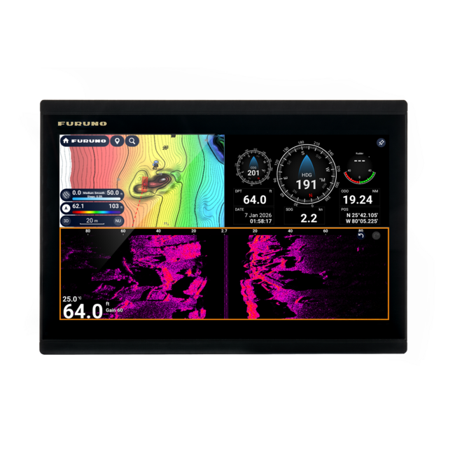
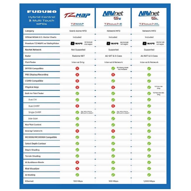
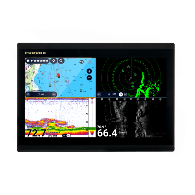
- Display: 12.8" all-glass multi-touch IPS screen with Full HD resolution, 1920 x 1080 pixels, and split-screen capability with up to 4 windows. The TZMAP13 is a stand-alone MFD, not a multi-MFD network display.
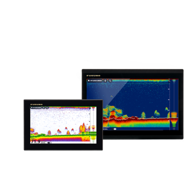
- Built-in sonar: internal TruEcho CHIRP/CW fish finder with support for 300 W, 600 W or 1 kW setups depending on the transducer, plus CHIRP Side-Scan at 230/455 kHz for depth, structure and side-view imaging.
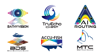
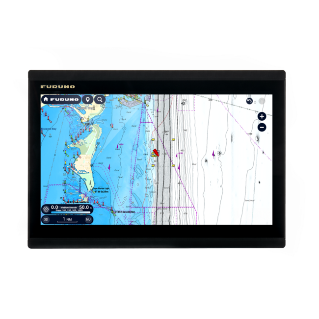
- Chart support: full integration with TZ MAPS and compatible chart options, including features such as BathyVision and AI Routing when supported by the selected chart region and unlocked data.
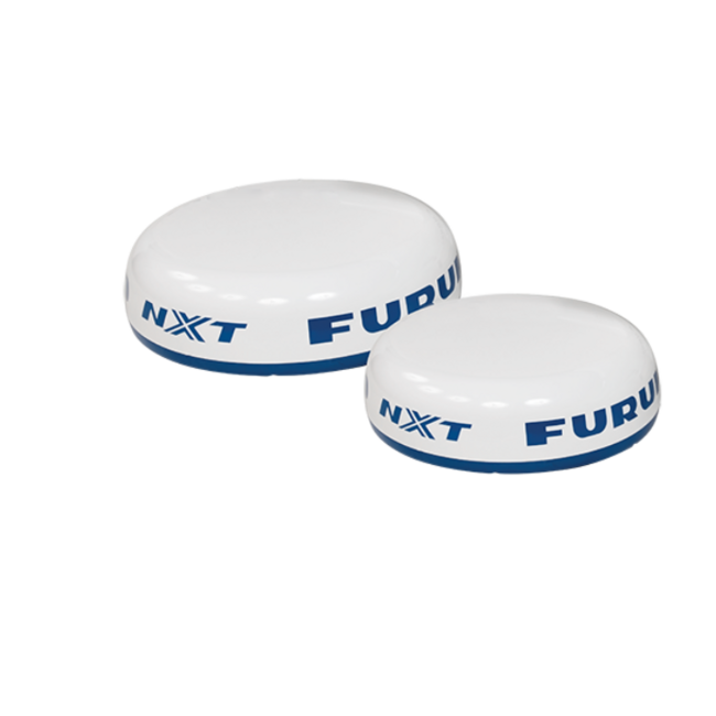
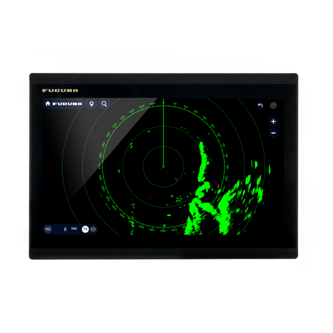
- Radar and data integration: compatible with selected Furuno radar sensors such as DRS2D-NXT and DRS4D-NXT, plus onboard data via NMEA 2000, NMEA 0183 and Wireless LAN.
- Robust marine design: waterproof construction for marine use, with IPX7 protection according to the supplied product information.
- Expansion and data management: connection options for sensors, radar and onboard data sources. The USB Type-C port is used for importing and exporting data such as software updates and user information.
Advanced Furuno Navigation in One Stand-Alone Display
The TZMAP13 is built for boats where one strong display is the most efficient solution. It works as a stand-alone MFD, giving the helm a clean, powerful control point for navigation, sonar, Side-Scan, selected radar data and onboard information.
Its operating logic follows Furuno’s modern touch-display experience, with edge-swipe operation, intuitive gestures and split-screen layouts. The result is a fast, premium interface where the skipper can zoom charts, switch views, mark waypoints and organise navigation information from one compact screen, without building a larger multi-display system.
This makes the TZMAP13 especially relevant for:
- Sailing yachts and motor yachts that need one compact Furuno chartplotter instead of a larger multi-display system
- Compact helms where dashboard space is limited but the skipper still wants reliable charting, sonar and navigation control
- Boat owners entering the Furuno chartplotter line-up with a stand-alone MFD that keeps the system simple and easy to manage
- Single-station setups where one screen is enough for charts, fish finder, Side-Scan, selected radar data and onboard information
- Fishing boats and cruising boats that want a compact display with stronger navigation and fish detection capability than a basic chartplotter
TZ MAPS for Smarter Route Planning and Richer Chart Detail
The TZMAP13 uses TZ MAPS, Furuno and TIMEZERO’s advanced chart platform, to give the skipper a more visual and data-rich navigation environment. For coastal cruising, marina approaches, channels, shallow areas and fishing grounds, this makes the display more useful than a simple plotting screen.
Depending on the selected chart region and unlocked chart data, TZ MAPS can support official hydrographic chart data, BathyVision bathymetry, satellite imagery, terrain and depth shading, community edits, user-created chart objects and AI Routing.
AI Routing can create a point-to-point route using chart data, vessel draft and selected safety parameters. It helps reduce planning time, while the final route check remains under the skipper’s control.
Built-In TruEcho CHIRP Fish Finder and CHIRP Side-Scan
The TZMAP13 is a strong choice for fishing because the fish finder is built into the display. It supports TruEcho CHIRP or CW fish finder operation with 300 W, 600 W or 1 kW output depending on the connected compatible Furuno transducer.
Traditional sonar helps show depth, bottom profile and fish targets below the hull, while CHIRP Side-Scan helps reveal structure, objects and fish targets to port and starboard. For anglers working wrecks, channels, drop-offs, seabed contours or structure, this gives a much clearer way to read the water before deciding where to fish.
Important sonar capabilities include:
- CW frequency support: 50/200 kHz
- CHIRP range: 40 to 240 kHz
- Side-Scan frequencies: 230 kHz or 455 kHz, depending on transducer
- Fish finder output: 300 W, 600 W or 1 kW, depending on setup
- Side-Scan display range: up to 750 feet to each side
- Fishing functions: ACCU-FISH, Bottom Discrimination, A-Scope, Bottom Zoom and Bottom Lock, depending on compatible transducer and setup
The transducer choice is critical. A well-matched Furuno or Airmar transducer can make a major difference in target separation, bottom reading and Side-Scan performance.
Radar, Autopilot and Connected Onboard Data
The TZMAP13 can connect with selected onboard systems to create a more capable single-screen navigation station. Compatible Furuno radar options include DRS2D-NXT and DRS4D-NXT, with radar adding stronger situational awareness for night navigation, poor visibility, rain, busy waterways and coastline monitoring.
For radar overlay and stable radar presentation, suitable heading data should be planned correctly as part of the system.
The TZMAP13 can also work with:
- NMEA 2000 data
- NMEA 0183 output via the power/data cable
- AIS data over NMEA 2000
- Engine, tank and fuel data through compatible NMEA 2000 gateways
- NAVpilot-300 and NAVpilot-711C autopilot control via NMEA 2000
- Wireless LAN for connected services such as TZ Weather
- My TimeZero Cloud for saving and synchronising user data
See the TZMAP13 alongside other Furuno display options and get a clearer view of the functions available across compact Furuno navigation setups.
Fleet Tracking and Connected TZ Features
With Furuno’s myTimeZero Cloud, user data can be saved and synchronised, helping keep routes, points and selected navigation information more accessible across compatible TZ environments.
One standout feature is fleet tracking when both vessels use TZtouch E or TZMAP and are connected to the internet through myTimeZero Cloud. This can allow a mothership to monitor a tender or dinghy’s position, speed, depth and other available information.
This is useful when sending a dinghy ahead to check depth in unfamiliar water, monitoring tender movement during excursions or keeping connected navigation information available between compatible Furuno displays.
Technical Specifications
- Brand: Furuno
- Model: TZMAP13
- Product type: 13" stand-alone multifunction display / chartplotter / fish finder
- Display size: 12.8" wide
- Display type: all-glass multi-touch IPS display
- Resolution: Full HD, 1920 x 1080 pixels
- Split screen: up to 4 windows
- GNSS: built-in GNSS for position, navigation and time data
- Cartography: TZ MAPS and compatible chart options
- Fish finder: built-in TruEcho CHIRP/CW fish finder
- Side-Scan: CHIRP Side-Scan, 230 kHz or 455 kHz depending on transducer
- Radar compatibility: selected Furuno radar sensors, including DRS2D-NXT and DRS4D-NXT
- Networking: NMEA 2000, NMEA 0183, Wireless LAN and Ethernet 100 Mbps
- USB: 1 x USB Type-C for data import/export and software updates
- Memory: 30,000 user points, 100,000 track points and 200 routes
- Waterproofing: IPX7 according to supplied product information
- Power supply: 12-24 VDC
- Mounting: bracket mount or flush mount
Compatibility Details That Matter Before Ordering
Before choosing the TZMAP13, check the details that directly affect installation and performance:
- Use TZMAP13 as a stand-alone display. TZMAP units are designed as stand-alone MFDs and are not intended to operate as networked multi-MFD displays.
- Choose a compatible radar sensor. TZMAP13 supports selected Furuno radar sensors, including DRS2D-NXT and DRS4D-NXT. Compatibility should be checked before reusing an existing radar.
- Plan heading data for radar overlay. Radar overlay and stable radar presentation require suitable heading data from compatible onboard equipment.
- Match the transducer to the fish finder setup. The internal fish finder supports specific CW, CHIRP and Side-Scan configurations. The transducer must match the desired sonar performance.
- Check supported Side-Scan combinations. Side-Scan can be used with supported sonar configurations, but not every dual-CHIRP or mixed transducer arrangement is supported.
- Confirm TZ MAPS requirements. AI Routing, BathyVision, satellite imagery and other advanced chart features depend on the selected chart region, unlocked data and available coverage.
- Use NMEA 2000 for onboard integration. AIS, engine data, tank data, sensor input and autopilot control depend on compatible NMEA 2000 equipment and gateways.
What Comes with the Furuno TZMAP13
The Furuno TZMAP13 is supplied with:
- 12.8" display unit
- Power cable
- Mounting bracket
- Mounting knobs
- Silicone rubber cover
- Quick guide and installation manuals
- Standard installation materials
Frequently Asked Questions About the Furuno TZMAP13
- Is the Furuno TZMAP13 a stand-alone MFD? Yes. The TZMAP13 is a stand-alone multifunction display designed to operate as one main helm screen for navigation, fish finder, Side-Scan and selected radar integration.
- Does the Furuno TZMAP13 have built-in GPS? Yes. The TZMAP13 includes built-in GNSS positioning, giving the display its own position source for navigation.
- Does the Furuno TZMAP13 include a fish finder? Yes. The TZMAP13 includes a built-in TruEcho CHIRP or CW fish finder with 300 W, 600 W or 1 kW support depending on the transducer setup. It also supports CHIRP Side-Scan at 230 kHz or 455 kHz with compatible transducers.
- Which radar sensors work with the TZMAP13? The TZMAP13 is compatible with selected Furuno compact radar sensors, including DRS2D-NXT and DRS4D-NXT. Radar compatibility should be checked before purchase, especially if the boat already has an existing radar sensor.
- Can the TZMAP13 control an autopilot? Yes. The TZMAP13 can interface with Furuno NAVpilot-300 and NAVpilot-711C autopilot systems via NMEA 2000, with autopilot control available from the display when correctly configured.
- Is the TZMAP13 good for fishing boats? Yes. The TZMAP13 is a strong option for fishing boats because it combines TZ MAPS, built-in TruEcho CHIRP fish finder, CHIRP Side-Scan, waypoint management and selected radar compatibility in one compact Furuno display.
A High-Performance Furuno MFD for a Smarter Long-Term Upgrade Investement
The Furuno TZMAP13 is a strong investment for boat owners who want to build a cleaner, more capable helm around one advanced display. It brings together modern Furuno charting, powerful fish finder technology, Side-Scan, selected radar compatibility and onboard data integration in a compact 13" format designed for long-term use.
At Sail360, our team selects marine electronics with a clear focus on quality, technical relevance and real onboard value. We prioritise high-technology products from trusted marine brands, so boat owners can invest in equipment that improves navigation, supports better decision-making and fits the way their boat is actually used.
Whether you are upgrading a small helm, building a compact fishing setup or replacing separate chartplotter and fish finder screens with a more capable Furuno display, Sail360 helps you buy with clearer technical information and stronger confidence in the investment.
Brochure
Furuno TZMAP13 and TZMAP9 Product Specifications
Furuno TZMAP9 & TZMAP13 Frequently Asked Questions
Furuno TZMAP Series Product Brochure