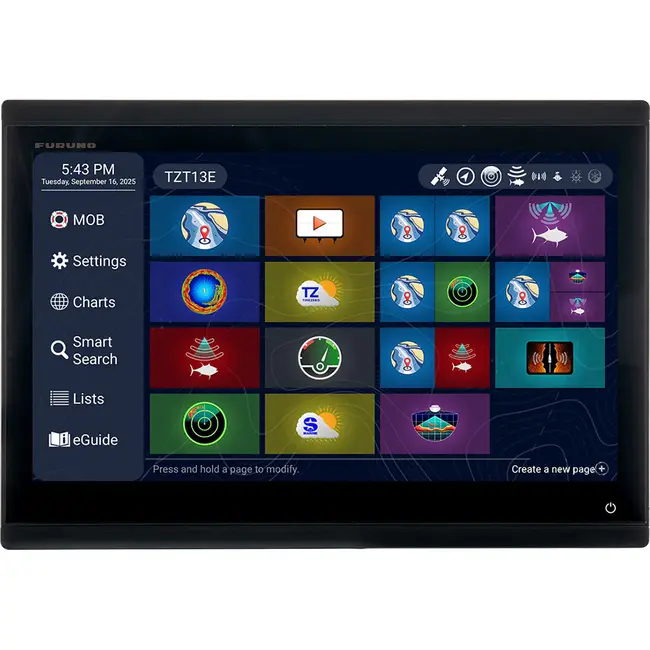
Discover the FURUNO NAVNet TZT13E: a 12.8-inch all-glass multi-touch MFD with Full HD resolution, integrated sonar, and full network integration. Ideal for boaters looking for a reliable, user-friendly navigation and fish finder solution. Read more.
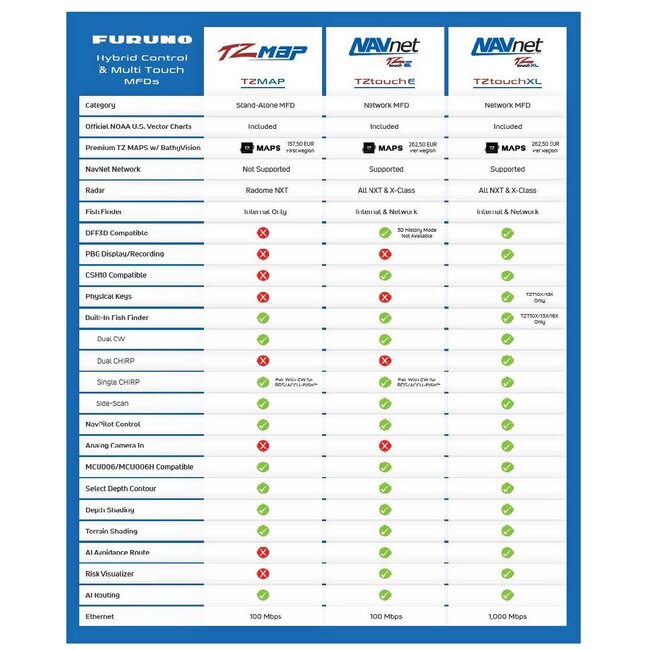
The FURUNO NAVNet TZT13E is an advanced network MFD (Multi-Function Display) that provides boaters with a streamlined, intuitive navigation and fish finder experience. This 12.8-inch all-glass, Full HD IPS display offers an innovative "all-touch" interface with no physical buttons, allowing you to switch between various functions instantly and efficiently. Unlike the TZT13X model – which uses both touch and traditional buttons – the TZT13E is fully touchscreen, making for a modern and sleek design. The TZT13E is part of the NAVnet TZtouch E series, along with the 9-inch model (TZT9E). Both screens are fully networkable and easily link to radars, AIS systems, autopilots and other marine sensors via Ethernet. With full radar compatibility, integrated sonar functions and support for the latest TZ MAPS software, you not only get a clear overview of the sailing route, but also real-time information about bottom structures and fish detection.
- Display: 12.8-inch all-glass multi-touch IPS display with Full HD resolution (1920 x 1080 pixels) and split-screen capability (up to 4 windows).
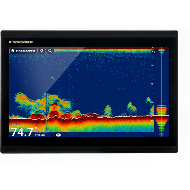
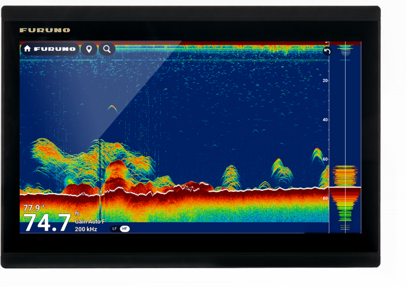
- Built-in Sonar: Features an internal 1kW TruEcho Single CHIRP/CW and support for CHIRP Side-Scan (230/455kHz), providing both depth and side-scan images.
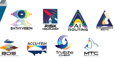
- **Map Support:** Full integration with TZ MAPS, including features such as BathyVision for accurate depth readings and AI Routing for intelligent heading planning.
- Networking Capabilities: Seamlessly connects to radar DRS series, AIS, autopilots, advanced sonar modules and other marine equipment via NMEA2000, NMEA0183 and Wireless LAN.
- **Rugged and Waterproof:** IP56 certified for optimal protection in marine conditions and suitable for use on boats of all sizes.
- **Extensibility:** Ability to pair with additional sensors and external antennas for a complete and personalized navigation experience.

- Comes with the 12.8-inch screen,
- power cable,
- Mounting bracket
- Standard mounting material.
- Purchasing the device also unlocks access to TZ MAPS features.
Multifunction Touch Screen (MFD):
Whether you're building a full-featured helm station or expanding your TZtouchXL network, these powerful 9- and 13-inch multi-touch IPS Series E displays offer advanced mapping, radar, fishfinder and video integration, powered by the intuitive TZtouchXL platform.
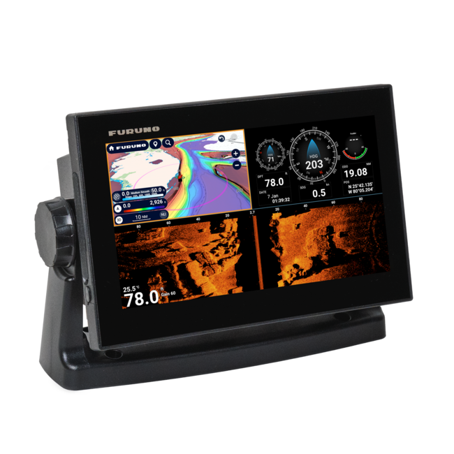
With this top-of-the-range TZT13E model, both navigation and fish finder functions are perfectly integrated, allowing you to rely on accurate depth data, bottom structures and real-time fish detection while sailing. This device, which serves as both a navigation system with a built-in fish finder, uses the Furuno advanced Time Zero chart system, which provides you with immediate insight into crucial water information. The multifunctionality is reflected in features such as an intuitive touchscreen interface, which allows you to easily zoom in and out of digital charts and instantly switch to sonar and sonar views. This means that every user, whether you are an experienced skipper or just starting out in boating, will benefit from an improved navigation experience on the boat. The Efficient Chartplotter TZT13E with time Zero offers expandability to TZT13X displays and offers not only streamlined navigation, but also the flexibility to connect additional sensors and external antennas, which is crucial for dynamic conditions on the water. Robust connectivity and regular firmware updates ensure that you always have access to the most up-to-date and accurate information, allowing you to navigate narrow channels and busy waterways safely. In addition, the integrated sonar and sonar technology ensures that you get a complete picture of both the depth and the underwater structure, detecting obstacles and fish-rich areas in time. This not only prevents unexpected situations, but also increases efficiency when manoeuvring in difficult conditions. The extensive expansion options also make the chartplotter ideal for users who want to create a complete and personal navigation location, where the connection with other marine systems is easy. Combining an intuitive interface and powerful processing capabilities, this system is a reliable partner for both recreational anglers and professional users in the marine sector. The display of digital charts on a high-definition Time Zero provides a clear overview of the sailing route, making navigation not only efficient but also extremely user-friendly for the less experienced skipper. This advanced technology combines the safety of accurate positioning with the flexibility of a multi-function system, resulting in improved course planning, real-time adaptation to water conditions and an optimal boating experience for every situation.
With TZ MAPS, you decide which map data you want to download, whether that's large map areas, satellite photos and bathymetric data. Depth hues and bathymetric data overlays create navigation charts with unrivalled detail and clarity, displayed with a variety of colour themes for an electronic mapping experience that surpasses all previous premium mapping services. You can create your own objects or update existing objects, such as buoys. When these change from their original position, they are immediately updated in the system. Custom user objects can be shared with other registered TZ MAPS users The purchase of a TZ MAPS area also unlocks additional functionality, such as powerful AI routing that intelligently plans routes, taking into account the boat's draught, mapped depths, and navigational obstacles. With the purchase of a TZ MAPS map, you can access those maps in the free TZ iBoat app for mobile devices such as a phone or tablet. This free home planning app transfers your waypoints and routes directly to the TZtouch With a free TimeZero account, you can easily backup or retrieve waypoints and routes from the cloud with just a few taps. This way, all your carefully constructed data is kept safe.
BathyVision for TZ MAPS provides you with unparalleled bathymetric data with contour lines that can be configured with just one tap. With a resolution of just 7.6 cm between the contour lines – that's 3 times better than any other bathymetric card on the market today. The bathymetric data is generated from the same high-resolution database used for TZ MAPS' custom depth coloration and can be overlaid on the navigational charts to create fish charts that are amazing.
TZ Weather offers shipping worldwide a better insight into the weather situation and more accurate weather forecasts. The free TZ Weather service delivers global and regional weather forecasts from NOAA's Global Forecast System (GFS) for any area you choose. With a premium subscription, you can download higher-resolution data from a variety of global models, including ICON, NAM CONUS, Arpège, and AROME. You can configure your MFD to download the latest weather information right at startup.
Find your safe haven and your anchorages by integrating real-time weather forecasts with TZ MAPS' mapping technology. With date selection and the downloaded current weather forecast, the system automatically analyzes the expected wind conditions and topography to provide a clear, color-coded anchorage status: green for sheltered, orange for partially sheltered, and red for exposed. These anchorages are extracted from high-resolution vector maps and complemented by contributions from the TIMEZERO "Community Maps" network, ensuring an up-to-date and comprehensive database of anchorages.
You need a radar for your own safety Whether you're navigating fog, monitoring traffic, or keeping an eye on storms, these multifunction displays (MFDs) provide you with unparalleled on-board situational awareness. Whether you choose the X-Class microwave option or the NXT Solid-State Doppler models, Furuno Radar delivers unprecedented power and clarity, providing the assurance that you are navigating with the most reliable and versatile equipment in the world. From the compact DRS2DNXT/DRS4DNXT domes to the powerful 100- watt or 200-watt DRS25ANXT open array, you'll get used to the features that only Furuno offers you very quickly, such as Target Analyzer™ that warns you of potentially dangerous objects, Fast Target Tracking that displays a speed and heading vector in seconds, the industry-leading Bird Mode to track elusive flocks and even individual birds that hunt baitfish, and Rain Mode that can display the objects you need to see, even during the heaviest showers, in different colors. In addition, TZtouchXL introduces new radar features, such as Risk Visualizer™ and AI Avoidance Route™, that help you stay safe on the water.
- Risk Visualizer™ en AI Avoidance Route™
Risk Visualizer™ is a unique feature of Furuno radars that provides a visual representation of potential collision risks with approaching objects around the ship. Unlike CPA/TCPA alarms, which only indicate the risks visible on the vessel's current course, Risk Visualizer™ assesses all objects around the vessel 360°. Dynamic icons are automatically generated for objects with the highest probability of collision, providing the captain with the necessary information to maintain safe distances while passing. The new AI Avoidance Route™ feature, available with TZ MAPS, uses all the information from the radar to instantly determine and offer a safe route around the hazards.
-Never lose waypoints, routes or settings again with TZ Cloud.
Create your routes at home using TZ Navigator, a web browser* or the TZ iBoat iOS app, then download them from the cloud to your TZtouchE MFD. You can also back up and retrieve all your events on your MFD at home, as your data is automatically and securely synced. TZ Cloud stores all your markers, routes, boundaries, photos and catch data. With a free TimeZero account, you can backup or retrieve all your data with just a few taps. Purchasing a TZ MAPS map directly through the MFD also unlocks these maps in the free TZ iBoat app for mobile devices such as a phone or tablet and the TZ Pro navigation software. This is the only home scheduling solution you'll ever need.
Without Side Scan
With Side Scan
Brochure NAVNet TZT13E and 9E Multifunction Touch Screens Fish Finder/Chartplotter