TZ Professional software was created to meet the navigation demands and requirements of all professional sailors. It offers a wide range features as well as optional modules and charts to enhance your experience. Read more.
TZ Professional software was created to meet the navigation demands and requirements of all professional seafarers. It offers a wide range features as well as optional modules and charts to enhance your experience. TIMEZERO software has two key goals: supreme control and performance. The TimeZero Professional You can run it on a Windows Computer and run it on two screens. Meaning, you can have your chartplotter in screen 1 and your sounder in screen 2.
Cutting edge Software for Professional Navigation
NAVIGATION TYPES
While safety and performance remain the cornerstones for any professional at sea, other requirements like a dedicated workspace, compatibility and the processing of your instruments data and the impact of specific weather variations are vital for some and less so for others.
The TZ Navigator Software in combination with additional models can make it ideal for:
COMPATIBILITY WITH S-63 CHARTS
Keeping with current charts is critical to ensuring the safety of everyone at sea. The official encrypted S-63 charts are compatible with TZ Professional. Every week, the S-63 charts are updated. These maps comply with the International Maritime Organization's (IMO) S-52 standard. The iconography offers a simplified display in order to improve the readability of the marine charts on-screen.

ADVANCED ROUTE MANAGEMENT
Route planning is critical for all maritime professionals.
TIMEZERO´s unique technology ensures the security of a route from the moment it is created: Color codes (green/red) allow you to instantly determine whether the depth is suitable for your boat's safe passage. An computerized route wizard will advise you on the best departure and arrival times, taking tides and currents into consideration.

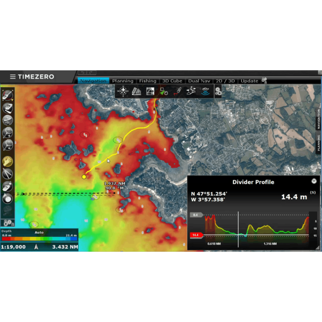
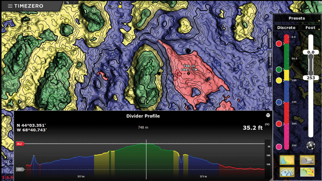
PROFILE WINDOW
This new took displays a point-to-point depth profile window instantly. This 2D perspective will allow you to spot depth changes (rocks, shipwrecks, etc.) with unrivaled precision.

FISHING WORKSPACE
A workspace dedicated to professional fishers, which allows for the customization of 2D/3D so that the most relevant information is displayed first.

SECURITY CONE
The new security cone is a feature that adheres to the IMO's approved guidelines. It uses the information from vector charts to find isolated risks and shallow regions. An anti-grounding warning will be activated automatically if an obstacle is identified inside this cone in front of the boat's path.

USER INTERFACE
When it comes to handling all of your navigation data as well as all of the other features that have made TIMEZERO a major success for more than 30 years, the user interface of TZ Professional is straightforward and simple to use.
WEATHER AND TIDES
This weather tool is simple to use and provides 24 hour access to weather forecasts globally.
Free Weather forecasting, because no navigator will plan a route without a trustworthy weather prediction. TIMEZERO provides all users with free access to current data.
TIMEZERO Weather Wizard can directly download and display weather and oceanic data.

Examine how weather data is incorporated into TIMEZERO software:
TIMEZERO is one of the world's leading suppliers of maritime weather, with about one million weather files downloaded each year. It allows you to directly overlay meteorological and oceanic data on your chart.
The latest version of TZ Navigator now includes GFS model forecasts with a 0.25° precision.
Free and limitless forecasting for up to 15 days with global coverage:

To get your weather data, simply send your personalized weather service request and receive a downloadable file by internet or by email. The file size is quite small at around a few KB.
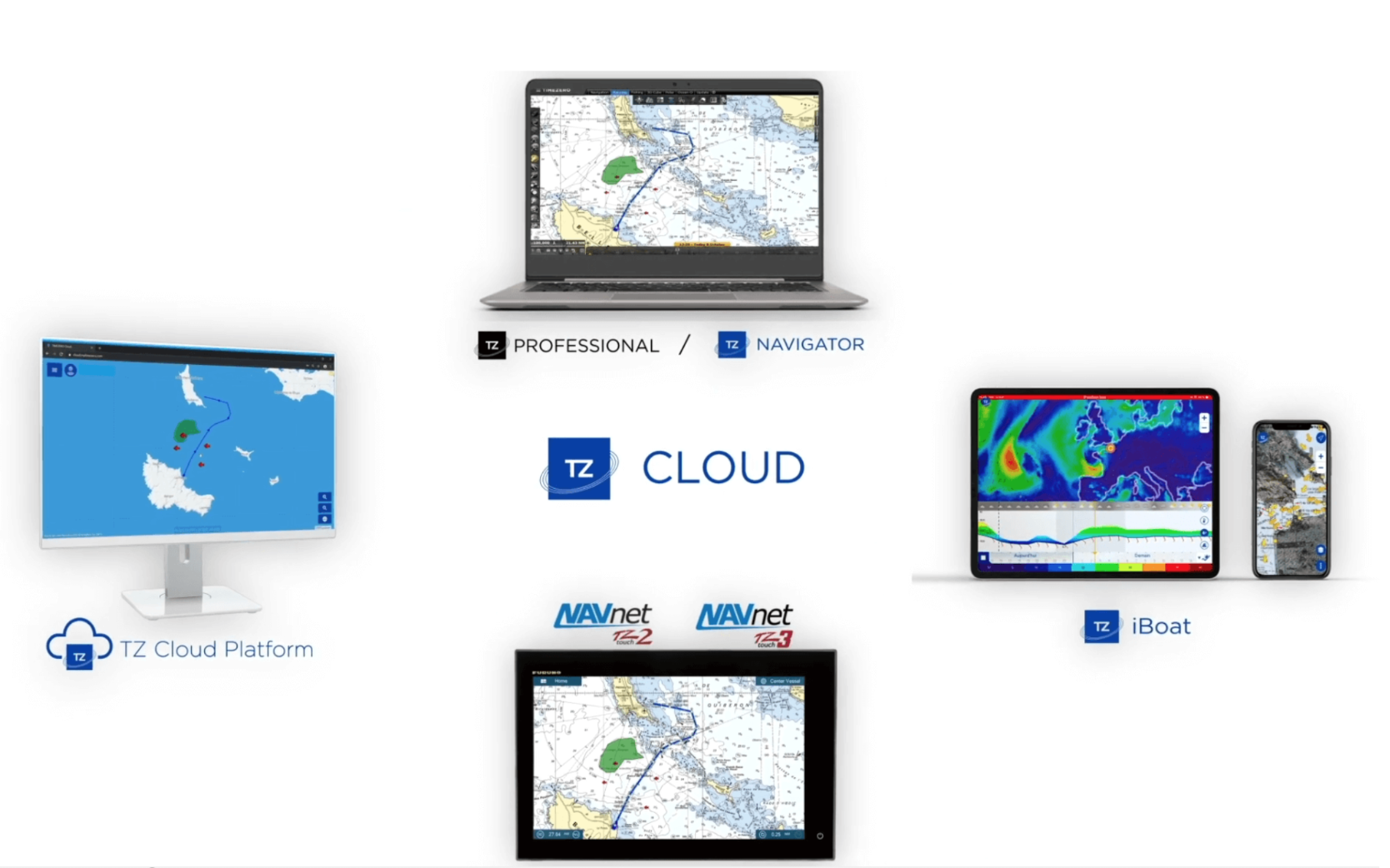
SYNCRONIZATION CLOUD
With TZ Cloud, your data follows you wherever you go and is always available.
Discover the revolutionary TIMEZERO - FURUNO ecosystem for securing your navigation data.
TIMEZERO protects your navigation data with the new TZ Cloud technology. You will not need to export your markings, images, routes, or zones since they will be automatically preserved and safeguarded.
TZ Cloud also provides real-time synchronization between all TIMEZERO systems and the FURUNO NavNet TZtouch2 MFD.
Discover how the TZ Cloud works:
TZ Cloud eliminates data loss
The new TZ Cloud service, which is available for all TIMEZERO products and the FURUNO NavNet TZtouch2, handles your data automatically in an easy and safe manner.
If you wish to retrieve your navigation data from home, but your navigation computer is still aboard your yacht, you may view your data by entering into your MyTIMEZERO account. You may access your synced navigation data at any time and place.
TZ Cloud automatically saves:
Share your data between TIMEZERO platforms
If you require a backup navigation system, the synchronization mechanism allows several TIMEZERO software products or other TIMEZERO compatible platforms to exchange your data automatically. For instance, the iPad and iPhone app TZ iBoat can instantly synchronize with the TIMEZERO PC program. There's no need to use a wire or a flash drive to manually transfer your data. The routes and marks are instantly shared via TZ Cloud.
TZ Cloud's synchronization provides unrivaled on-board comfort. In fact, you won't need to replicate your markings, zones, or routes from now on. Inside the boat, navigate using your PC, and the information will be instantly copied on the TZ iBoat app and the FURUNO NavNet TZtouch2 MFD.
Use any device to access your navigation data
You may also review your navigation data using your web browser (Google Chrome, Microsoft Edge, or Mozilla Firefox) with the new TZ Cloud service. The online platform displays your markings, surfaces, routes, and images on your computer, tablet, or smartphone.
When you create or alter an object on your TIMEZERO PC Software, TZ iBoat app, or FURUNO NavNet TZtouch2 or TZtouch3 MFD, the ecosystem instantly synchronizes to show your data on the new cloud platform: cloud.mytimezero.com.
You must be connected to the internet and login into your MyTIMEZERO account to use this free feature.
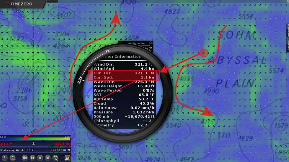
OCEAN-O
The Ocean-O feature helps to easily identify fishing zones by collecting and analyzing oceanographic data.
It successfully identifies zones with a high possibility of containing fish while lowering operational expenses and the degree of environmental impact simply by going right to the source.
The altimetry identification service, geostrophic currents, sea surface temperature SST, and plankton and chlorophyll concentration are all at your disposal to help you plan fishing excursions more quickly, easily, and intelligently. TIMEZERO´s forecast workspace offers a free platform for accessing both oceanographic and weather forecasts.
To receive this data, all that is needed is an internet connection.
AIS/ARPA TARGETS
The configuration of AIS might be complicated at times. TIMEZERO´s new AIS module enables comprehensive setting of all information (Status, Destination, etc.) within TZ Professional. Furthermore, AIS text messages may now be received and sent via TZ Professional. This technology will allow for simplified, free and individual communication with all vessels equipped with AIS. Finally, by identifying speed ranges that correspond to the speeds of fishing boats, it is feasible to rapidly identify vessels that are actively fishing.

Recognize nearby targets and predict their moves.
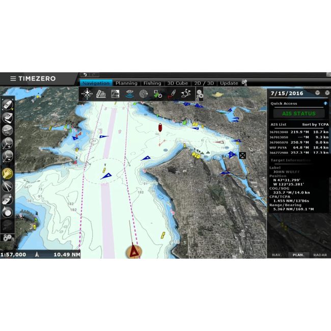
With the TIMEZERO software, monitor your navigation zone. Display targets in table format with all necessary information using TIMEZERO's AIS/ARPA capability. Avoid collisions by monitoring the movements of surrounding boats and programming the anti-collision warnings based on your chosen criteria.
Integrated within all of the TIMEZERO range, the AIS/ARPA feature allows you to:
Automatic Identification System (AIS)
Since the development of the radar, AIS has been regarded as the most crucial invention for marine security. When linked to TIMEZERO, your AIS system provides a complete picture of the traffic in your area.
The International Maritime Organization (IMO) highly advises equipping your vessel with AIS to increase navigation security.
The identification method automatically detects a considerably greater zone than those covered by VTS radar stations at a cheap cost. Within this larger zone, approaching boat directions and speeds are detected, and anti-collision precautions are implemented automatically.
Using AIS, surveillance centers can handle the most essential traffic with the same personnel. In addition, it supplies a VHF network for port operations. The AIS function accomplishes two goals: it improves security and it responds in situations of emergency.
Automatic Radar Plotting Aid (ARPA)
Today, the vast majority of commercial boats have been equipped with an ARPA radar to alert users of potential accidents. These anti-collision radars are also now reasonably priced for most recreational vessels. If you are unsure if you are presently sensing possible crashes and you are driving in a congested location, this tool will assist you in avoiding potential risks.
While some systems provide trustworthy data, they are frequently difficult to comprehend. The objectives are presented immediately inside the chart and can even be captured when using AIS/ARPA for TIMEZERO.
A simple click on a target will provide its speed, CPA, and TCPA. A table with all of the necessary information will show after a double click. All of this information may be captured and saved for later use.

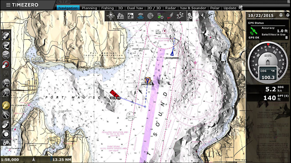
CHART ENGINE
View the most important data from both land and water in real time.
TIMEZERO technology provides notable ease of use and exceptional power to TIMEZERO software. Because of its unique technology, all of the software provides you with a flawless and continuous chart display. The combination of PhotoFusion with a unique 2D/3D chart engine allows for the simultaneous visualization of all critical data on a single screen. Even when using pan and zoom, the navigation is seamless with no redraw time.

Have access to worldwide maps thanks to the mm3d charts*, which are compatible with TZ Professional. Its global coverage is accessible in raster and vector charts (C-MAP). TIMEZERO technology also includes an unrivaled chart engine that automatically combines maritime charts, 3D data, and satellite pictures via PhotoFusion.
*the TZ charts are sold separately (check our webshop for Mega-Wide and Wide Vector charts)

Optional:
Notes:
(1) - TZ Professional can only be installed on one computer
(2) - Connection to the Pilot can be done using NMEA0183 (via a Serial COM Port) or using NMEA2000 (via Actisense NGT1-USB Gateway)
These complementary modules are sold separately (see related products)
TIMEZERO provides a number of additional modules that will improve your navigation experience by routing, displaying neighboring objects, and acquiring crucial seabed data.
TZ Radar Module (with Furuno Ethernet Radar) includes:
TZ Sounder Module (with Furuno Ethernet Sounder) includes:
TZ Weather Routing Module includes:
TZ PBG Module includes:
TZ WASSP Multi-Beam Module (3)
TZ DFF3D Module (3)
TZ Trawl Positionning Module
TZ Bottom Hardness Module (3)
Record (via NMEA0183) the Bottom Hardness output by:
TZ Camera and Augmented Reality Module includes:
TZ Host Output Module includes:
TZ S57/ S63 charts Module
TZ VDR (Voyage Data Recorder) Module
Notes:
(3) - You must have the PBG Module first, in order to be able to acquire the WASSP or DFF3D module or Bottom Hardness module.
If you wish to have an extra work station, it can be added at an additional cost (see related products for more)
In order to use the TZ Professional Software technology and its cutting-edge capabilities, you must meet the system requirements listed below: