TZ Navigator is a cutting edge software that was created to meet the navigation needs and expectations of recreational sailors. It is ideal for cruisers, sailors and racers and offers a wide range features as well as optional modules and charts. Read more.
TZ Navigator is a recreational software that is suitable for all forms of maritime navigation.
The TZ Navigator program was created to meet the navigation needs and expectations of recreational sailors. It is a software that takes you from cruising with your powerboat or yacht to competing in regattas, with cutting-edge features. The TIMEZERO program has two primary goals: supreme control and comfort.
The cutting edge software for recreational navigation
NAVIGATION TYPES
Sailing kinds vary greatly, and whether you wish to cruise or relax in your powerboat or yacht, or participate in regattas, you will have requirements that are specific to that type.
While safety and simplicity of use remain essential for all sailors, additional capabilities such as route planning, AIS functionality, radar overlay, and fish finder are more important for some than others.
The TZ Navigator Software in combination with additional models can make it ideal for:
MAPS
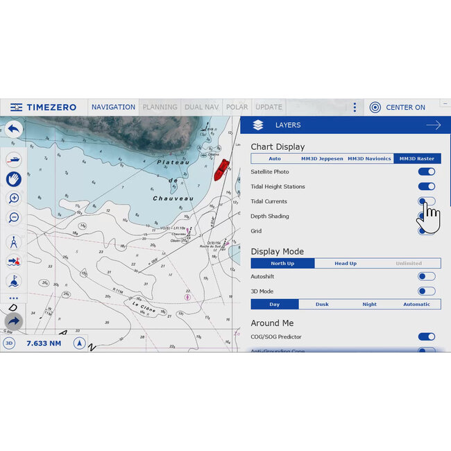
Have access to worldwide maps thanks to the mm3d charts*, which are compatible with the TZ Navigator. Its global coverage is accessible in raster and vector charts (C-MAP). TIMEZERO technology also includes an unrivaled chart engine that automatically combines maritime charts, 3D data, and satellite pictures via PhotoFusion.
*the TZ charts are sold separately (check our webshop for Mega-Wide and Wide Vector charts)

ROUTE PLANNING
The Route Planning Wizard lets you calculate departure time based on various factors (Tides, Currents, Transit Time, and so on). It's never been easier to arrive at high tide or depart the port with perfect current conditions.

Every boater understands the significance of route planning. This unique technology ensures the security of a route from the moment it is created.
Color codes (green/red) allow you to instantly determine whether the depth is suitable for your boat's safe passage.

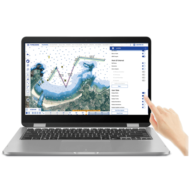
TARGETS AND POIs
A point-of-interest (POI) is a geographic location on a map at a specified latitude/longitude.
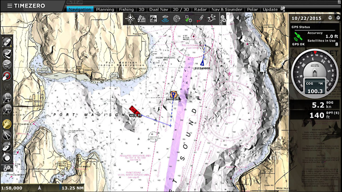
Navigate securely and with complete peace of mind! TIMEZERO is the first navigation program that have ActiveCaptain Points-of-Interest (POIs) integration and real-time updating. Your features also include the AIS (automatic identification system) capability by default.

INTERFACE
Because your software should be as comfortable as your boat, the most recent generation of user-friendly interfaces has been properly optimized for touch screen use.

AIS/ARPA TARGETS
Recognize nearby targets and predict their moves.
With the TIMEZERO software, monitor your navigation zone. Display targets in table format with all necessary information using TIMEZERO's AIS/ARPA capability. Avoid collisions by monitoring the movements of surrounding boats and programming the anti-collision warnings based on your chosen criteria.
Integrated within all of the TIMEZERO range, the AIS/ARPA feature allows you to:
Automatic Identification System (AIS)
Since the development of the radar, AIS has been regarded as the most crucial invention for marine security. When linked to TIMEZERO, your AIS system provides a complete picture of the traffic in your area.
The International Maritime Organization (IMO) highly advises equipping your vessel with AIS to increase navigation security.
The identification method automatically detects a considerably greater zone than those covered by VTS radar stations at a cheap cost. Within this larger zone, approaching boat directions and speeds are detected, and anti-collision precautions are implemented automatically.
Using AIS, surveillance centers can handle the most essential traffic with the same personnel. In addition, it supplies a VHF network for port operations. The AIS function accomplishes two goals: it improves security and it responds in situations of emergency.
Automatic Radar Plotting Aid (ARPA)
Today, the vast majority of commercial boats have been equipped with an ARPA radar to alert users of potential accidents. These anti-collision radars are also now reasonably priced for most recreational vessels. If you are unsure if you are presently sensing possible crashes and you are driving in a congested location, this tool will assist you in avoiding potential risks.
While some systems provide trustworthy data, they are frequently difficult to comprehend. The objectives are presented immediately inside the chart and can even be captured when using AIS/ARPA for TIMEZERO.
A simple click on a target will provide its speed, CPA, and TCPA. A table with all of the necessary information will show after a double click. All of this information may be captured and saved for later use.

WEATHER AND TIDES
This weather tool is simple to use and provides 24 hour access to weather forecasts globally.
Free Weather forecasting, because no navigator will plan a route without a trustworthy weather prediction. TIMEZERO provides all users with free access to current data.
TIMEZERO Weather Wizard can directly download and display weather and oceanic data.

Examine how weather data is incorporated into TIMEZERO software:
TIMEZERO is one of the world's leading suppliers of maritime weather, with about one million weather files downloaded each year. It allows you to directly overlay meteorological and oceanic data on your chart.
The latest version of TZ Navigator now includes GFS model forecasts with a 0.25° precision.
Free and limitless forecasting for up to 15 days with global coverage:

To get your weather data, simply send your personalized weather service request and receive a downloadable file by internet or by email. The file size is quite small at around a few KB.
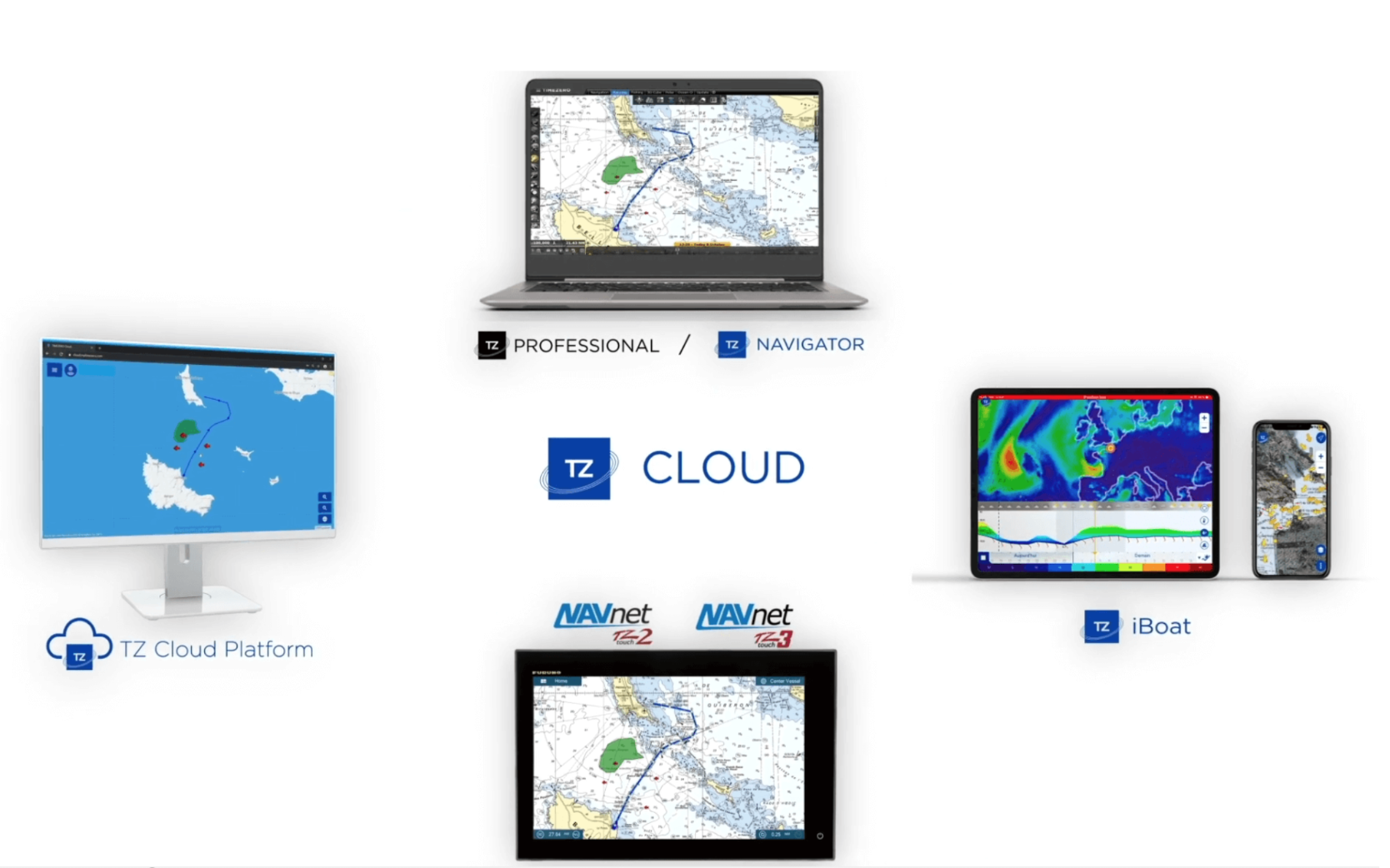
SYNCRONIZATION CLOUD
With TZ Cloud, your data follows you wherever you go and is always available.
Discover the revolutionary TIMEZERO - FURUNO ecosystem for securing your navigation data.
TIMEZERO protects your navigation data with the new TZ Cloud technology. You will not need to export your markings, images, routes, or zones since they will be automatically preserved and safeguarded.
TZ Cloud also provides real-time synchronization between all TIMEZERO systems and the FURUNO NavNet TZtouch2 MFD.
Discover how the TZ Cloud works:
TZ Cloud eliminates data loss
The new TZ Cloud service, which is available for all TIMEZERO products and the FURUNO NavNet TZtouch2, handles your data automatically in an easy and safe manner.
If you wish to retrieve your navigation data from home, but your navigation computer is still aboard your yacht, you may view your data by entering into your MyTIMEZERO account. You may access your synced navigation data at any time and place.
TZ Cloud automatically saves:
Share your data between TIMEZERO platforms
If you require a backup navigation system, the synchronization mechanism allows several TIMEZERO software products or other TIMEZERO compatible platforms to exchange your data automatically. For instance, the iPad and iPhone app TZ iBoat can instantly synchronize with the TIMEZERO PC program. There's no need to use a wire or a flash drive to manually transfer your data. The routes and marks are instantly shared via TZ Cloud.
TZ Cloud's synchronization provides unrivaled on-board comfort. In fact, you won't need to replicate your markings, zones, or routes from now on. Inside the boat, navigate using your PC, and the information will be instantly copied on the TZ iBoat app and the FURUNO NavNet TZtouch2 MFD.
Use any device to access your navigation data
You may also review your navigation data using your web browser (Google Chrome, Microsoft Edge, or Mozilla Firefox) with the new TZ Cloud service. The online platform displays your markings, surfaces, routes, and images on your computer, tablet, or smartphone.
When you create or alter an object on your TIMEZERO PC Software, TZ iBoat app, or FURUNO NavNet TZtouch2 or TZtouch3 MFD, the ecosystem instantly synchronizes to show your data on the new cloud platform: cloud.mytimezero.com.
You must be connected to the internet and login into your MyTIMEZERO account to use this free feature.
SECURITY CONE
The new security cone is a feature that adheres to the IMO's approved guidelines. It uses the information from vector charts* to find isolated risks and shallow regions. An anti-grounding warning will be activated automatically if an obstacle is identified inside this cone in front of the boat's trajectory.
*vector charts sold separately

ODOMETER
The new Odometer NavData automatically displays your trip information including Duration, Distance, Max Speed and Average speed.

FURUNO ADVANCED COMPATIBILITY
A simple Ethernet connection allows you to connect to any Furuno NavNet system. Users may use TZ Navigator to effortlessly access and control vital information from their NavNet network, such as Radar Overlay, Waypoints, and Routes.
Optional
Notes
(1) - TZ Navigator can be installed on two computers
(2) - Connection to the Pilot can be done using NMEA0183 (via a Serial COM Port) or using NMEA2000 (via Actisense NGT1-USB Gateway)
OPTIONAL ADDITIONAL FEATURE
These complementary modules are sold separately (see related products)
TIMEZERO provides a number of additional modules that will improve your navigation experience by routing, displaying neighboring objects, and acquiring crucial seabed data.
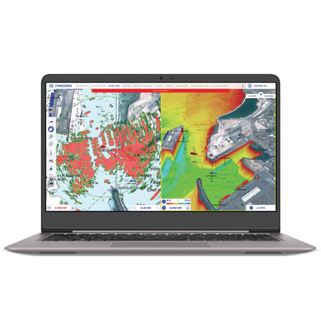
TZ Radar Module (with Furuno Ethernet Radar) includes:
TZ Sounder Module (with Furuno Ethernet Sounder) includes:
TZ Weather Routing Module includes:
If you wish to have an extra work station, it can be added at an additional cost (see related products for more)
In order to use the TZ Navigator Software technology and its cutting-edge capabilities, you must meet the system requirements listed below: