Update for your MegaWide Charts for both Vector and Raster type charts, created by TimeZero. It lets you stay up to date with the latest navigation data and features. Read more.
Update for your MegaWide Charts for both Vector and Raster type charts, created by TimeZero. It lets you stay up to date with the latest navigation data and features without needing to repurchase a whole new chart.
IMPORTANT
Altimetry
TIMEZERO and Furuno NavNet(3D & TZT) use MapMedia.mm3d altimetry to portray the shoreline correctly. There are several benefits, such as fast identification of port entry or identification of certain shoreline characteristics. Altimetry also enables you to maneuver in a realistic perspective view with respect to the horizon.

Satellite Photographs
TIMEZERO and Furuno NavNet(3D & TZT) use satellite photos in an innovative and entertaining technique known as PhotoFusion. This innovative technology combines satellite photographs with raster or vector charts to deliver only the information required for safe navigation in a simple, realistic manner. Included with each .mm3d data pack is a standard resolution satellite photographs. Only select areas have high definition satellite photos. MapMedia continues to collaborate with data providers to expand and update the collection of satellite photographs.

Bathymetry
MapMedia .mm3d bathymetry is based on the visual interpretation of chart contour lines. This 3D model is highly useful while entering a port or harbor, offering another navigation tool to keep you aware of underwater threats.

The S-52 Vector Chart Standard
The International Hydrographic Office (IHO) produces the S52 standard. S-52 is an internationally accepted standard that governs electronic vector chart presentation and iconography to make it easier to read and comprehend. MapMedia.mm3d vector charts meet this worldwide standard.


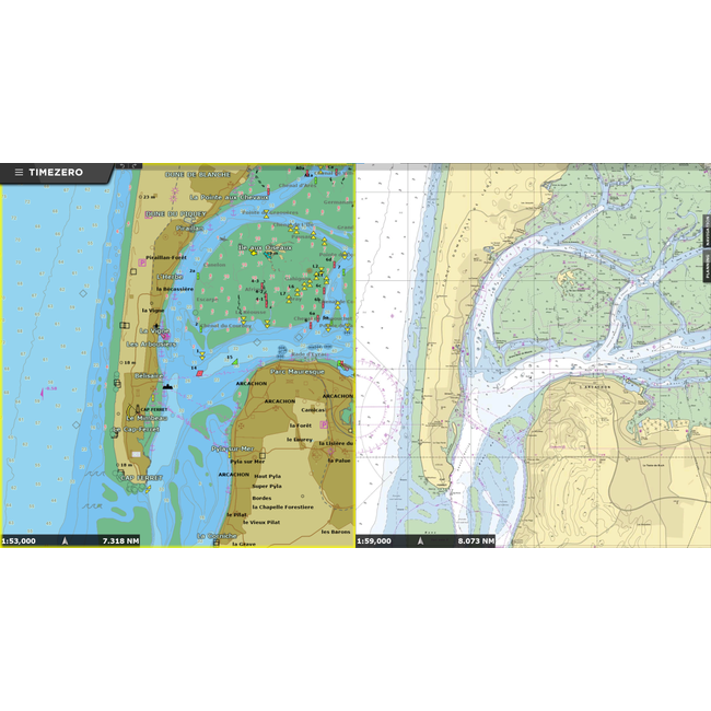
(Vector: left side / Raster: right side)
Raster Charts:
Raster Charts are an identical representation of the traditional nautical paper charts, since they are digital scans of printed lithographic charts. This is ideal for users that have always used nautical paper charts because they are able to find the exact same information on screen.
Pros:
Cons
Vector Charts:
Vector Charts are a rendering of a lithographic chart in a point-by-point format. Vector charts are composed of mathematically defined geometric shapes: lines, objects, and fills. The data is stored in a database and drawn on the computer or plotter screen by the software, making the display different from Raster Charts.
Pros:
Cons:
After entering your address and payment details, please provide your ID code and the device on which you intend to use the chard in the comment section. You will receive an instruction email with the registration code required to install the chart on your device.
Press MENU --> INITIAL SETUP --> Scroll to the bottom of the list and turn CHART MASTER to ON.
Just under CHART MASTER you see System ID Code
Note: If more than one unit is going to be in the system - only one unit should be set as CHART MASTER.
TimeZero:
FURUNO:

")